


Mick Sagrillo March 30, 2015
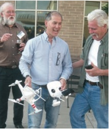
Robert Foster, Charles Newcomb, and Roger Dixon. Newcomb uses the Phantom 2 Vision drone, shown here, in wind turbine site assessments. Find specifications for this drone at http://bit.ly/1ueO1vf.
This past June at the annual Small Wind Conference in Stevens Point, Wisconsin, Charles Newcomb of Endurance Wind Power concluded a presentation with a tantalizing look at the future of wind turbine site assessments: the use of drones.
Drones are remotely piloted unmanned aerial vehicles, small flying robots controlled by a person on the ground. Drones have been in the news of late, not only for their military use, but also because they are now affordable consumer “toys.” Newcomb’s presentation was not about using the type of drone deployed by the military for reconnaissance, surveillance, or as a weapon, but rather the consumer product known as a “flying camera.”
These devices weigh in at only a few pounds, yet are capable of carrying a considerable “payload.” For the purpose of assisting with wind site assessments, the primary payload is a small digital camera and global positioning system (GPS), both built into the drone. The drone is controlled with a pair of joysticks by an operator viewing what is happening on a smart phone, via a wi-fi connection. The phone screen can display the position of the drone including height, speed, and GPS location, as well as plot the distance between two points and report compass directions.
The value of these three data points is readily apparent to any wind site assessor. The purpose of a wind site assessment is twofold—to evaluate and qualify a site for the suitability of a wind turbine and to specify the minimum acceptable tower height for that site to optimize the wind resource based on the height of the obstacles in the area, typically trees and buildings. Once this is done, estimating or modeling the wind resource at hub height can proceed. Knowing the rules of thumb for reducing the impact of trees and buildings on a wind turbine’s performance, one of a site assessor’s primary jobs is to site the tower so as to optimize the “fuel”—the wind.
Historically, site assessors have used a variety of tools and techniques to determine the height obstacles that could either interfere with the wind flow or create turbulence, both of which diminish the quality and quantity of the wind. The historic tools used were borrowed from the logging industry. A clinometer or story pole is used to determine a tree’s height. If you know the distance from the person using the clinometer to the tree, some trig or the appropriate spreadsheet can calculate the tree height in question. Given a site cluttered with trees and buildings in multiple directions, this becomes a time-consuming task.
A drone, with the ability to quickly fly from point to point, not only reduces the time involved but also adds a level of accuracy that can be difficult to achieve for the earth-bound. (Remember, however, that the accuracy of any tool is only as good as the person using it.) With the ability to hover as well as fly, the drone’s camera gives the operator a “hummingbird’s eye view” of the terrain and its obstacles relative to the turbine’s proposed hub height.
Distance and height are logged on a smart phone with an app that comes with the drone. Screen shots of the smart phone can be taken for that particular site and saved for that client’s file. The drone and screen shots really enhance boots-on-the-ground site assessments, but they don’t replace wind maps, online wind resource estimators, or computer programs that simulate or model the site in question.
Interestingly, several companies are market.ing online site assessment services—“no site visit required”—with hit or miss results.
A seasoned wind site assessor understands the value of such tools, but also knows that they cannot replace an actual site visit. Each tool, online modeling program, and boots-on-the-ground site visit, complements the other, and both contribute to qualifying the site. Some site assessors use an online simulator to prequalify a site for a client, and only conduct a site visit if the site holds promise. On completion of the site assessment, an assessor will use wind maps and online wind resource estimators to derive the average annual wind speed at hub height.
In complex terrain or areas with a lot of ground clutter and obstacles, site assessors have been known to fly a weather balloon or kite in order to determine where above the ground the turbulence caused by the obstacles diminishes. One payload that we flew after Newcomb’s presentation was a long line of string with plastic streamers tied every 20 feet over its length. The streamers flutter in the turbulence like a flag, but will fly straight once above the turbulence, helping the assessor “see” where turbulence ends and laminar wind flow begins.
Mick Sagrillo (msagrillo@ wizunwired.net) teaches and consults about wind power, and has powered his home with wind since 1982.